The Flying Trip of a Lifetime
by
Fr. Bill Menzel
On the afternoon of Jan. 31, 1999, Super Bowl Sunday, I drove out to Alexander Field, the Wisconsin Rapids airport, to begin an adventure that I had dreamed of for a long time. This is a narrative of that adventure. It was originally written at the request of a friend who works at the Federal Aviation Administration Automated Flight Service Station in Green Bay. I have rewritten it for the sake of readers who may not be as familiar with aviation terminology as he is. Here’s the story.
The Background
For about 15 years, my parents have rented a condominium near Marco Island, Fl., during the month of February. For many of those years, I have been able to spend some time with them, enjoying a brief respite from work and from the rigors of Wisconsin’s winter weather. Marco Island is far south on the Gulf side of Florida’s peninsula.
At age 58 and a pilot for more than thirty years, I’m still an airport bum, so the fact that the Marco Island Executive Airport is walking distance from their condo has added to the enjoyment of the days I’ve spent there. At a brisk pace I can be at the airport in 17 minutes, and I can watch and wander among everything from Waco biplanes, a two-wing design from the 1930s, to Falcon Fan-jets and other multi-million dollar business jets that whisk the wealthy around the nation and the world.
I realized during these visits that watching, though fun, was not quite enough. So, for years, I dreamed of flying myself from home in Wisconsin Rapids to this idyllic airport astride the mangroves of southwest Florida. In early 1999, I finally was able to live that dream.
During the years I had dreamed about making this flight, I had become somewhat picky. A slow aircraft wouldn’t do. It would take too long, and I wouldn’t have as much time to spend with the folks. The plane also had to be well-equipped for instrument flight. ("Instrument flight" usually means flying in clouds, where it is impossible to see the ground or other visual references outside the airplane, such as the sun or, at night, the stars and moon. In order to fly in conditions like this, a pilot must have an "Instrument Rating," and the aircraft must have certain instruments for navigation that would not be necessary for visual flight.)
In late winter of 1998, a Mooney M20J was purchased by a local physician and became available for rental. The Mooney M20J was manufactured in 1978; it is a refinement of an aircraft originally designed by Al Mooney in the 1950s. It is a single-engine, four-seater, with a cruising speed of 178 miles per hour. In any case, I immediately fell in love with it and began plotting and planning for my dream trip the following February.
To the casual observer, the Mooney looks quite small. I guess maybe it is, but it’s surprisingly comfortable for a 6-foot 7-inch pilot like me. It has a lot of leg room but is a little stingy on head room. Before I ever flew the airplane, I sat in it for literally hours. I explored the leg room and the tilt of the seat back. I tested rudder pedals and control-yoke movement. (The control-yoke can be turned like a car’s steering wheel, and it can also be pushed in or pulled out. It is used to steer the airplane and to point it up or down.) I experimented with different methods of getting into and out of the plane. I checked the head room and hip room. I memorized the locations of all the switches and gauges and controls. By the time I took the check-ride in the airplane (a requirement for renting it), I knew that I was comfortable with it and in it. But I didn’t know if I would be comfortable flying it.
Well, it was love at first flight. The check-ride in the Mooney, as all check-rides in a plane one hasn’t flown before, had its rough edges. But I liked the way it felt, and I could tell that it liked me, too. (Those of us who love flying erroneously believe that airplanes have souls.)
That was in May of 1998. Over the next months, I flew the Mooney about an hour a month, always using a hood to simulate instrument conditions, except for one night flight in October that I flew visually. A Methodist minister friend flew as my safety pilot, which is required when practicing simulated instrument flight. I had to have confidence in my ability to fly this bird on instruments. That came with the practice. It’s a nice instrument ship, and fortunately, I love instrument flying.
The Mooney was equipped with a navigation device called Global Positioning System, popularly known by its initials GPS. This piece of equipment receives signals from satellites orbiting a couple hundred miles above the earth, and it is capable of giving pilots all sorts of navigation information, such as position, speed, path along the ground, estimated time en route and just about anything else they would need or want to know. It doesn’t tell where the nearest McDonald’s is...yet.
Using the GPS was a new experience for me, and it took me a long time to gain familiarity with it. Unfortunately, the operator’s handbook was unavailable. However, I was able to download an authentic working simulator of this model from the manufacturer’s website, along with any documentation I could possibly need. The simulator, which operates on a computer, turned out to be a great way to learn the intricacies of its performance.
So now I had the aircraft that I wanted for the trip to Florida, and I had a verbal commitment from those who controlled its rental that I could use it for the 10 days in February. Now, I had to save the money--a process most people understand, so I won’t go into detail here.
Finally, I had to do the flight planning. In reality, I had been doing this since I first learned that I might actually be able to make my dream flight. Even before I got checked out in the Mooney, I began to log onto DUAT, a special service for pilots, for some initial planning. As time went on, I learned more and more about using this excellent resource. By the time winter rolled into Wisconsin, I was confident in my ability to do all the necessary flight planning and flight plan filing, using DUAT and an old laptop computer that was given to me in early December.
With money I received as Christmas gifts, I purchased three items: a battery for the laptop computer I had been given, an electronic carbon monoxide detector for the aircraft, and for backup in case of electrical failure in the aircraft, a handheld (portable) GPS. This latter device was almost as full-featured as the one mounted in the aircraft, and it had one optional display called "Horizontal Situation Indicator" (or HSI--pilots love abbreviations) that proved to be particularly useful. (Simply put, an HSI display always shows two important bits of information in one glance: the direction you are actually going and the direction of your destination.)
Now it was just a matter of waiting until the big day finally arrived. I watched the weather between Wisconsin Rapids and Marco Island just about every day. I watched as winter storm systems marched across the country, and I tried to guess what each one would do along my route of flight, which was essentially a straight line from Alexander Field through Lovell Field in Chattanooga, Tenn. to Marco Island Executive Airport. In all of my planning, I left some flexibility to deal with the variables, especially the weather.
The Trip Begins
Originally, I had planned to leave on Monday, Feb. 1 and make the trip from Wisconsin Rapids to Marco Island all in one day, with a stop at Chattanooga for fuel and other necessities. This plan assumed favorable tailwinds. As the time got closer, I left open the option to leave on Sunday afternoon, Jan. 31, with an overnight stop somewhere down the line. As it turned out, that was a good move.
After watching the weather for a few days just prior to my departure, I made the decision to leave on Sunday afternoon, Jan. 31. An ice storm hit central Wisconsin the next morning, but I was many miles south by then. When I left home, the plan was to stop at Chattanooga for the night, refuel there, and continue on to Marco Island on Monday. That’s not the way it worked out.
Airborne from Wisconsin Rapids by 2:15 p.m. on Super Bowl Sunday, with an instrument flight plan to Chattanooga, I quickly found that I was bucking a strong headwind. This made my speed over the ground frustratingly low. Anticipating this possibility, I had canceled my motel reservation in Chattanooga before I left Rapids; I didn’t want the pressure of "having to get there" clouding my decision-making.
Since I have a personal policy of not flying into my last hour of fuel, I made the en route decision, based on ground speeds at times as low as 130 mph, to stop at Terre Haute, Ind. for fuel. Having flown over half the trip from Wisconsin Rapids to Terre Haute in solid instrument conditions, and having to fly an instrument approach to the Terre Haute airport and land there with strong crosswinds, and hearing the forecast for Chattanooga to be for instrument conditions with strong crosswinds on the main runway, I decided to spend the night at Terre Haute. I was tired after the weekend’s schedule at church, and a night landing at Chattanooga under the forecast conditions did not appeal to me.
I stayed at the Larry Bird Hotel in Terre Haute, where I watched the Super Bowl between Denver and Atlanta (rather dull, as you may remember) and had a good meal. With the adrenaline flowing as it was from the excitement of the trip, not to mention a terribly noisy heating system in the room, I slept only so-so, but the decision to stop there overnight was a good one.
Marco on Monday
For Monday’s flight to Marco Island, one stop for fuel would be required, so from my hotel room, I filed two flight plans: one from Terre Haute to Albany, Ga., and then from Albany to Marco Island. The forecast en route weather was not real attractive, with mostly instrument conditions and a continuing strong southerly flow aloft, which, of course, meant headwinds and slow ground speeds. Terre Haute was under instrument conditions when I left, and after entering the overcast shortly following takeoff, with one 3-minute exception between Terre Haute and Evansville, Ind., I never saw the ground again until I was 200 feet above the runway at Albany. As all pilots would know, that’s a lot of very demanding flying--more than three hours’ worth.
Between Terre Haute and Evansville, I began to pick up light, clear ice at 7,000 feet. It was the oddest stuff I’d ever seen--like little tentacles grabbing on to the leading edge of the wing and then flowing back a few inches. I announced my concern to the air-traffic controller. He was most helpful (I think they pick up on that different pitch your voice gets when you begin to collect ice), and he immediately cleared me down to my requested 5,000 feet and told me that lower was available if I wanted it. The ice left even more quickly than it had collected, though, and that was my one and only encounter with ice on the entire trip (for which I am mightily grateful, as ice is my least favorite cargo; I do not like being a test pilot for new wing shapes, which is essentially what ice makes you.)
The Albany airport, as hundreds of other airports in the United States, has an automated weather-reporting system that pilots can pick up on their radios; it gives the pilot a constantly updated report on the weather at the airport. About 70 miles out, I tuned in the Albany weather. Reception at that distance was intermittent. Did I hear the voice say "ceiling 200 feet overcast, visibility 2 miles"? After a few more miles passed below me, the reception was better. Yes, I had heard right. This would be a very challenging instrument approach to the runway at Albany. I was glad that I had practiced all those instrument approaches at Central Wisconsin Airport during the summer and fall.
All that practice made the instrument approach to Albany relatively uneventful, and that’s the way it should be. I looked up at decision height (where you have to decide whether you will land or go around), and there was the runway. This kind of flying really focuses the mind!
After emptying my bladder and refueling my body and the airplane at Albany, I launched back up into the 200-foot overcast and continued on over southern Georgia and northern Florida at 7,000 feet in almost solid instrument conditions. Then, gradually, the clouds began to break, and about an hour after leaving Albany, I found myself in mostly visual conditions, with occasional clumps of piled-up cumulus clouds. So, I bumped through the clumps (every cumulus cloud holds at least one nice jolt) and otherwise enjoyed smooth air and good visibility. The farther south I got in Florida, the smoother the air, the more I was able to just relax and enjoy the scenery, and the more grateful I felt for the privilege of being able to be up there actually doing what many people only dream of.
Near Tampa, the controller told me that there was traffic at 8 o’clock (you have to imagine that you are sitting on a clock; the nose of the plane is 12 o’clock, so 8 o’clock is to your left and a bit behind you) and 12 miles away, a United Airlines Boeing 737 descending through 12,000 feet. I was at 7,000 feet and was to let the controller know when I had the traffic in sight. There was a thin, scattered layer of clouds above me, which was in the way, but it was not long before the Boeing eased through the vapors and appeared in all its majesty. Something so large and graceful in flight is truly a marvel to behold. After telling the controller that I had the traffic in sight and being directed to maintain visual separation from the airliner, I watched as it drifted from left to right across my flight path, descended through my altitude, and then made a gentle right turn into Tampa’s traffic pattern. In my 1,700 hours of flying, I have never tired of watching airplanes fly. It’s even more beautiful up here than it is looking up from the ground.
The Mooney I was flying is, by my standards as a renter pilot, a very well-equipped airplane. Besides a lot of electronic equipment for navigation and communication, it also has a simple but very useful autopilot. I used it constantly during the trip except for the most demanding situations, where I trusted me more than it. With the help of the panel-mounted GPS and my portable model attached to the yoke in front of me, I always knew exactly where I was, how fast I was going, and how long it would take to get anywhere. Satellites hundreds of miles above were holding my hand. Amazing!
I arrived at Marco Island around 5:30 p.m. on Monday, Feb. 1. It was the only easy approach and landing of the entire trip--and even on this one, a Learjet landing ahead of me forced me to make a 360-degree turn (like a holding-pattern, this is a way an airplane can "stop", while still flying) during my final approach as he taxied back and off the runway.
After landing at Marco Island, I arranged for parking and fuel. Then I called my folks and started walking toward their condo, as I needed the exercise; the Mooney is comfortable, but it had been a long sit. We met about halfway, drove back to pick up my bags, and then began a very relaxing 9 days of wonderful weather and welcome change of pace.
The Return
At 1 p.m. on Wednesday, Feb. 10, I left Marco Island and started for home. The first stop would be at the Atlanta DeKalb-Peachtree airport to visit a friend who is a flight instructor there. Dan, the youngest of three brothers from Eau Claire whom I’ve known since they were kids, is working toward a career in flying. We keep in close contact and had arranged that I would stop there and spend the night, then head home on Thursday.
The three brothers have a nickname for me that they use all the time; they call me "Magic," a name coined by Dan’s older brother Mark, because he was impressed by the fact that I knew how to wire stereo systems and use computers. If you’re wondering why I’m mentioning this nickname, you’ll soon find out.
The flight from Marco Island to Atlanta was relatively easy for the first hour or so, but as I got farther north, I started encountering more and more cumulus clouds. Some of these towering clouds did not take kindly to my presence and decided to toss me around a bit. The strike finder (an instrument in the plane that detects lightning) even began to show a little activity, but fortunately, it was to my right; I could see the cloud that was generating the activity. I passed through that area at just the right time, as by an hour or so later the cumulus clouds had closed ranks, and a line of thunderstorms had formed across northern Florida.
As I headed on toward Atlanta, the air got smoother, but the traffic situation got more intense. When I was finally handed off to Atlanta Approach Control, I checked in, "Atlanta Approach, Mooney 01 Tango with you at 6 with Quebec." (This means that I was telling him that I was at 6,000 feet and had the weather information at the airport where I would be landing. The "01 Tango" comes from the aircraft’s registration number, N1201T. This is the way small aircraft are usually identified in the modern air-traffic system. "Tango" is the way the letter "t" is pronounced in the International Radio-telephone Alphabet.) The controller replied, "01 Tango, Roger. Fly heading 070 for ILS 20 Left at Peachtree." I read back the heading, and then was surprised to hear a real quick, "Hi, Magic" on the frequency. I sent back a real quick, "Hi, Dan." The friend I would be meeting was up flying with a student and had been listening for me on the frequency. I don't think the controller even heard us, so fast did we squeeze in that exchange.
As I progressed toward Atlanta, the approach controller kept getting busier and busier. It was around 4:30 p.m., and all the birds were coming back to the nest. It got so hectic that he kept repeating to all the aircraft on his frequency, "Don't call me; I’ll call you!" Busy as he was, he kept good track of me. I don't think I added too much to his burden, except that I missed his first call when he gave me instructions to tune in the control tower at the airport where I would be landing. I heard him the second time.
Aside from the hectic traffic situation and the fact that I had never been here before, the landing at Atlanta was relatively easy. I taxied to a stop, arranged for refueling and overnight parking, and then walked the couple of blocks to Aviation Atlanta, where Dan works. When he finished with his student, we drove back to the plane to get my bags and computer, and then headed to his apartment. There, I met his roommate James, who just recently began flying with a Delta feeder airline.
That evening, I used my computer to check the weather before I went to bed, and the Thursday forecasts looked awful. A strong, moist, southerly flow was running into a big dome of cold air in the plains, and all of this was moving right toward my intended route of flight. It looked like some rather odd and ominous winter weather was a-brewin’.
Thursday morning, I got up around 7 and looked out the window at...fog. I turned on the computer and asked DUAT to give me all of the weather and weather maps for a flight from Atlanta back to Terre Haute. I thought that with the approaching wild weather, Terre Haute might be as far as I could get that day. I also looked at the hourly reports for Wisconsin. The southern part of the state wasn't too bad, but the central and north--including Wisconsin Rapids--had visibilities down to 1/4 mile in fog. My departure airport at Atlanta was showing a 200-foot ceiling and 1/2-mile visibility, so I filed an instrument flight plan with DUAT, and Dan and I headed for the field.
Thursday Tailwinds
By now, I was getting used to departing into low ceilings, so after goodbyes to Dan, I fired up the Mooney, took my time going through the checklist and joined the lineup of fast and fancy jets and turbo-props waiting to go at the end of the runway. Finally, I’m ready, cleared for takeoff and rolling down the runway, then flying. That’s always such a thrill when the wheels leave the ground. Gear up, flaps up, hello clouds, goodbye ground; turn right to the northwest heading I was assigned. Now, it’s just the Mooney, the controller and me. On top of the clouds in no time, the sun shone brilliantly into the cockpit--quite a change from the gloom below.
The flight to Terre Haute was wonderfully smooth and fast. I was on top or between cloud layers most of the time, but there were some delightful miles over Kentucky, where I could see the mountains and rivers.
I made my biggest error of the trip when Atlanta Center handed me off to Chattanooga Approach Control; I forgot to flip the switch on the radios, made my call to Chattanooga Approach (or so I thought), heard a mumbled response that I didn’t understand, and stayed dumb and happy for about 20 minutes. Suddenly, it dawned on me that all the radio chatter I was hearing was Atlanta Center, and I'm supposed to be hearing Chattanooga Approach. I looked at the switch and said, "O, no!" (or words to that effect.) I had visions of Approach Control making repeated attempts to call me, and I could almost hear the chewing out I was going to get. I flipped the switch, and before I even had a chance to utter a word, I heard, "Mooney 01 Tango, contact Atlanta Center on 133.6." I said, "01 Tango, Roger, 133.6, and I’m sorry that I goofed up." She comes back with, "That's O.K., 01 Tango. Have a nice flight."
Throughout the entire trip, I was treated uniformly well by all of the air-traffic controllers. At each hand-off I made a point of saying "thank you," and I meant it. Every controller who worked my flight was professional and helpful. After I crossed the Mason-Dixon Line, my Midwestern ears occasionally had to adjust to some new phonemes in the controllers’ speech, but I simply made an extra effort to "listen up." There were some in-flight routing changes, some of which were quite complicated, but I believe that a pilot has to be ready to cope with things like that. Controllers don’t make changes in our flight plans to make life miserable for us. They do it because complex circumstances make it necessary.
About a half hour after leaving Chattanooga’s airspace, while talking with Louisville Approach Control, I went over to Flight Service to get some updated weather. (Flight Service Stations are located in various parts of the country. They employ specialists who provide weather and flight planning information to pilots anywhere in the country by radio or telephone.)
The specialist was most helpful. His information made me begin to think that I just might be able to make it to Madison, Wis.--not my destination but close enough. I knew that any farther north was out of the question for that day. Because of the very strong tailwinds, my ground speeds between Atlanta and Terre Haute were in the neighborhood of 205 mph, plus or minus 10, so I was moving right along. I decided to stop at Terre Haute for fuel and to get another look at the weather. I could stay there again, if necessary.
The approach to Terre Haute was in turbulence that was very unpleasant below 3,300 feet. It really bounced me around. Winds on the field were gusting up to 35 mph, but they were blowing straight down runway 18, so at least there would be no crosswind to contend with. (Runways are numbered by their magnetic heading, excluding the last digit. For example, runway 18 is on a heading of 180 degrees, which is straight south.) My preference in windy conditions like that is to land with no flaps. (Flaps are on the back of the wings, close to the fuselage. On small planes, deploying them makes it possible to land with a slightly lower airspeed.)
The gusts made for hard work, but the landing went well. Knowing that the tower controllers were watching with keen interest, I quipped while on the abbreviated roll-out, "How’s that for a beginner?" The local controller offered, "Not bad, 01T. We’ve seen a lot worse today."
The line personnel refueled the plane very quickly, and I checked the weather on the computerized system available in the fixed-base operator’s flight-planning room. It showed that the line of thunderstorms was all the way from north-central Wisconsin down to Texas, but it seemed to be moving quite slowly toward the east. Confident that there were enough options along the way in case the weather got too bad, I filed an instrument flight plan to Madison. I knew that I wouldn’t be able to make it to Wisconsin Rapids that day. Madison would be good enough.
With the ground speeds I was getting likely to improve as I got closer to the center of the low-pressure area and the front not likely to get to Madison for at least two hours, it was worth a shot. I knew that if I stayed overnight at Terre Haute, I would have to face headwinds, turbulence and the possibility of icing on Friday, and I didn't like that a bit. Nor did I like the idea of having the Mooney sitting outside during an Indiana thunderstorm.
All of this turned out just right. I made it to Madison in less than two hours, with a ground speed of 237 mph at one point. With the lightning detector showing activity in every direction, I flew another instrument approach into Madison but was able to see the runway when I was still 4 miles out. Because of the strong headwinds, my ground speed on the approach to runway 18 was about 50 mph. Again, I chose to land without flaps.
The thunderstorm hit Madison just after the Mooney had been parked and tied down. It was about 2 p.m., and I was glad to get a motel and just relax for the rest of the day, and get a good night's sleep. The wild weather outside soon changed from rain to snow, and the wind howled all night long.
The Last Thirty Minutes
The next day, Friday, I waited until late morning to head to Wisconsin Aviation, the fixed-base operation where the plane was parked. They were just wonderful to me there, both when I arrived and when I was getting ready to depart. The driving rain in the thunderstorm had injected water into the keyholes of the Mooney, and of course, it froze overnight, so I couldn’t get into either opening. For $15, they towed the plane into a hangar and gave it more than an hour of hangar warmth. I went in after a while, and as a frigid wind howled outside, I inserted the key into the now-thawed locks, opened the doors, wiped the door seals dry, did the pre-flight, and added a quart of oil to the engine.
When all was ready, they towed me out, and I fired the bird up for the last leg--the only part of the trip that I flew under visual flight rules (VFR). After taking off into a gusty northwest gale, it was 30 minutes of incessant bumps from Madison to Wisconsin Rapids. The visibility sometimes was only in one direction because of snow flurries, but it was good to be heading home.
According to the automatic weather system, the winds at Wisconsin Rapids were from the northwest gusting to 35 mph, which would make runway 29 the preferred runway, with 40 degrees of gusty crosswind. Another no-flap landing. On final approach, I could see that the light, drifting snow was blowing straight down the runway. No crosswind. A nice touch. An easy touchdown. With a wind like that, it was a cinch to stop before the intersection of the two runways.
It’s Over
The Mooney and I trundled up to the hangar. The dream flight was over. As the cold wind whirled across the tarmac, I transferred all of my baggage from the plane to my car. It was good to be home, but in my heart, there was a quiet voice saying, "Wouldn’t it be nice to continue this adventure?" I answered Yes, then warmed up the car and drove away. In seven minutes, I was home.
All in all, this trip was quite an experience, and I’m glad I did it. I learned a lot, worked hard, had a good time and met many wonderful people along the way, both on the radio and at airport fixed-base operations.
I don’t know if I’ll ever get to do something like this again. I hope I will, but if not, that’s OK. The memories will last a lifetime.
Postscript
By November 1999, my friend, Dan, whom I visited in Atlanta, had been interviewing with the airlines for several weeks. He called one evening in mid-November, all excited. "I just got home," he said. "There was a letter from Comair in the mailbox. I dropped all the other mail and opened it right there. You’re the first one I’m calling. Comair wants me to start simulator training with them around the end of January or early February!" Comair is a rapidly growing regional airline, with hubs in Cincinnati and Orlando; Delta Airline is its majority stockholder. So, assuming that his simulator training goes well, Dan’s airline career soon will be taking off.
Post-Postscript
In early December 1999, Dan called to say that he got a better offer from SkyWest. Simulator training with them will begin in early January 2000.
Update on Dan
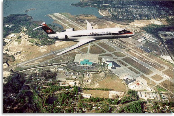
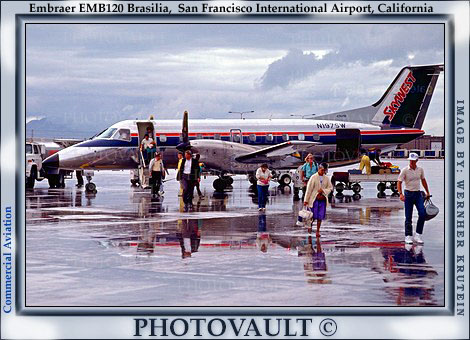
In early March 2000, Dan began flying for SkyWest, a regional airline flying United Express and Delta Connection routes, mostly in the West. When I wrote this in early June 2000, Dan was flying as First Officer (co-pilot) on the Embraer Brasilia. Below are pictures of Dan in uniform and the aircraft he was flying then, a 30-passenger turbo-prop. (Continued below the photos)...
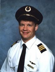 |
 |
In the Fall of 2001, Dan transitioned to SkyWest's 50-passenger regional jet. After flying as First Officer for about a year, he accepted the challenge to upgrade to Captain. So in December of 2002, Dan flew his first flight as Captain on SkyWest's regional jet. Captain means you're ultimately responsible for the conduct of the flight--the buck-stopper, so to speak.